How can satellite imaging, AI, and remote-sensing help build a greener and fairer world? We spoke to Space4Good to find out!
By Thomas Ansell
We previously spoke to Space4Good, the ground-breaking earth observation analytics agency and Hub member organisation, about how cutting-edge technology can help build a more peaceful and just world. Whether that’s by monitoring the building of latrines, detecting unexploded ordinances or using AI to model for climate risk to mitigate armed conflict.
Now we’re looking into the many ways that Space4Good’s technology can be used to help build a more green and fair world- and how the technology can be used to further nature-based solutions in the future.
Pest and disease tracking and monitoring
As the planet warms, areas of the globe become more and/or less suitable for growing certain crops. Both for construction (timber) or food. Environmental changes also change the risk profile for each crop from disease and pests. In Switzerland, for example, Space4Good used both Sentinel-2 imaging and environmental factors to determine the risk to trees for Bark Beetle infestations.
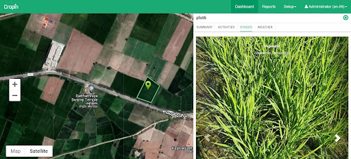
Meanwhile, in collaboration with CropIn (also a Humanity Hub member), CropLens has been set up. Within this project, Space4Good and Cropin are modelling pests and diseases to develop an early warning system for smallholder rice paddy farmers. This is aimed at better preparing smallholder farmers for infestations and also limiting the amount of pesticide needed to combat such events.
Illegal logging detection in Tropical Rainforests
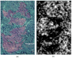
Illegal logging in globally important ecosystems is doubly problematic: not only does it erase a source of biodiversity, but it also releases huge amounts of carbon into the atmosphere. Whilst illegal loggers have methods to hide from enforcement on the ground, using Sentinel-1 and 2 imaging means that they can be observed in near real-time. The project has even gone one step further: integrating machine learning to help predict future deforestation based on existing patterns and parameters.
The project is being put to work in Indonesia, in collaboration with the Arsari Enviro Industri and Masarang Foundation, and can alert forest managers to illegal logging as it happens via unique alert systems.
Unlocking carbon financing using remote sensing
Space4Good is working with Rabobank on the ACORN carbon marketplace offering carbon assessments for smallholder agroforesters. These assessments offer certifiable credit insights that allow for carbon credits to be sold on Rabobank’s marketplace and facilitate sending financing back down to the smallholders to manage and expand their agroforestry efforts. Space4Good is also working on select carbon projects right here in the Netherlands and in Africa.
The future of using space technology for a greener world
Jessica Immelman, Business Lead at Space4Good, says: “In my time with Space4Good, I have had the privilege of being a part of cutting-edge projects whereby remote sensing data analytics and AI have unlocked countless opportunities with our partners to make informed, contextual, and science based management decisions for social and environmental impact. All too often, all we need is the perspective that earth observation can offer, as well as the opportunity to visualise occurrences on earth (past, present or future) to tell a story that can inspire changes necessary for a greener future.”
")


